The Walk to the Sea covers four centuries of Boston history. Beginning at the State House on Beacon Hill, overlooking the old Boston Common, the Walk passes historic monuments and skyscrapers. The Walk crosses a terrain that, centuries before, was not land at all, but an active port. The history of Boston is linked to the sea, whose smells and sounds once invaded the city. The walk from the top to the sea, which stretches for a mile and descends a hundred feet, gives life to that story.
Mayor Thomas Menino dedicated the Norman B. Leventhal Walk to the Sea in 2008.
Boston's Transformation
Massachusetts Bay to share his peninsula with its excellent springs. By 1634, hundreds of Puritans had usurped most of Blaxton’s land, leaving him with only 50 acres. He sold most of that land to the growing town for Boston's Common. Here, residents pastured their livestock, punished transgressors, and attended public assemblies.
Also in 1634, John Winthrop, governor of the Massachusetts Bay Colony, ordered a beacon placed atop the tallest peak of the original Trimount, giving Beacon Hill its name. He intended the beacon to warn of hostile ships, particularly the ships of King Charles I of England, who wished to reclaim the colony from Puritan control.
After the American Revolution, Beacon Hill became central to Boston’s rapid growth. The hilltop was carted away for fill, smoothing the way for new development. As portrayed at right, an elegant new State House replaced John Hancock’s estate, and wealthy insiders bought up Beacon Hill to sell as house lots. Within a few decades, gracious townhouses lined the new streets of Beacon Hill, and Boston Common became a park.
Around 1750, the present, stone version of King’s Chapel replaced the wooden structure of 1688. King James II had ordered the wooden chapel built. It was the first Anglican church in Boston, erected on the old burying ground over strong Puritan objections. Puritan power had weakened, and James had appointed a royal governor to administer the colonies of Massachusetts.
Behind the wooden chapel was the Boston Latin School. The Boston Latin School is the oldest American public school still operating, though at another Boston location. The school trained many of America’s founders, including Benjamin Franklin, Samuel Adams, and John Hancock.
On the site of the former Latin School now stands the Old City Hall, symbolizing the far more cosmopolitan spirit of Victorian Boston. Completed in 1865, it was an inspired example of the French Second Empire style, with its distinctive copper mansard roof, now a faded blue-green. The handsome building served until 1969, when the new City Hall opened nearby at Government Center.
The Walk to the Sea intersects two other historic trails through Boston, the Freedom Trail and the Black Heritage Trail.
Here, at Tremont Street, the red line of THE FREEDOM TRAIL® passes in front of King’s Chapel on its way to 16 national historic landmarks relating to the American Revolution. The trail begins at the Boston Common, two blocks south on Tremont Street. It passes through the old North End, where legendary patriots such as Paul Revere plotted to foil the British military strategy, and goes on to Bunker Hill and "Old Ironsides," the U.S.S. Constitution.
THE BLACK HERITAGE TRAIL® begins across from the State House at the memorial to the Massachusetts 54th Regiment, of Civil War fame. The trail leads to the west side of Beacon Hill, where Boston's vibrant nineteenth-century African-American community thrived. There, fugitive slaves found support and refuge on their way to freedom, and leaders of the black community, such as Lewis Hayden, worked to support the abolitionist cause.
The Scollay Square neighborhood stood here until the 1960s. Its colorful, Victorian buildings, bearing large painted advertisements, originally teemed with shoppers and theatergoers.
By the mid-20th century, however, this warren of 22 streets had become seedy. Scollay Square’s theaters became burlesque houses surrounded by bars and tattoo parlors that attracted sailors on leave.
Eventually, public opinion censured the lively squalor, and Scollay Square became a candidate for urban renewal. Its buildings were razed and replaced by the "superblocks" of Government Center, where, by 1969, a monumental new City Hall anchored a vast 10-acre plaza. Bostonians still debate the consequences of urban renewal, but the bold rebuilding reversed the decline in Boston's fortunes that occurred during the first half of the 20th century.
Mayor John Collins arrived on the scene in 1960. He picked Ed Logue to direct the Boston Redevelopment Authority. Together they reshaped downtown Boston.
Scollay Square was the second Boston neighborhood to be demolished for a modern rebuilding project. Collins and Logue envisioned in its place a new City Hall that would become the centerpiece for a rejuvenated downtown which vaulted Boston into the modern age.
The wooden Town House of 1657 stood here, its ground floor open to merchants, until the Great Fire of 1711. Two years later, the first bricks were laid for new offices for the Massachusetts colonial government.
The Old State House, the oldest public building in Boston, bears on its gables a gilded unicorn and lion. These symbols of English dominion were removed after the Revolution and later replaced by replicas. The building occupied Boston's most prominent intersection. King (now State) Street led from the Old State House to Long Wharf. Washington Street, the only street connecting Boston to the mainland, crossed King Street here.
Settlement and commerce grew around the building. Colonial governors looked down to Long Wharf from the balcony of the State House. Famous scenes of the American Revolution unfolded at its doorstep.
In 1798, Charles Bulfinch’s gold-domed State House opened atop Beacon Hill to begin a proud new era for Boston. The old, colonial State House passed on to other uses and, in 1881, to the protection of The Bostonian Society.
The Old State House appears as the backdrop in Paul Revere’s engraving of the Boston Massacre. When it was built, the Old State House overlooked bustling wharves. Ships were the source of Boston’s wealth. They also connected Boston politically and commercially to England and other countries and colonies. A different pulse now hums beneath the Old State House. Every day, thousands of commuters emerge from beneath the venerable building, where two of Boston’s busy subway lines intersect in the city's large financial district.
Crowded Boston planned its subway system in the Victorian era, when human and horsedrawn traffic overwhelmed its main streets. Boston was the first American city to build a subway, and the fourth city in the world, after London, Glasgow, and Budapest. The first segment of the subway system, now part of Boston’s Green Line, opened just uphill from here in 1897.
When the great Puritan Migration brought thousands to the coast of Massachusetts between 1630 and 1640, the waters of Boston’s Town Cove lapped the shore here. Early buildings, facing the sea, existed on only one side of Merchants Row.
Bostonians, however, continually added land among the old docks and built new wharves extending farther into the harbor. By 1711, construction on Long Wharf had filled in another block of King Street (now State Street), from which Long Wharf extended.
Merchants Row once led to the Town Dock. Bostonians filled in the dock in 1728 to make the land on which Faneuil Hall was completed in 1742. Ships could unload at the back of the market, as pictured at near right. Upstairs, a meeting hall hosted town business, lectures, and speeches, such as those of Revolutionary firebrand Samuel Adams.
Between 1824 and 1826, Boston added more land and three badly needed, new markets behind Faneuil Hall, including Quincy Market. In the 1970s, Boston renovated all four markets to create the first of America’s "festival marketplaces." Today, the marketplace eateries serve throngs of office workers and tourists. Faneuil Hall still hosts public events, and the shoreline has moved even farther out to sea.
Boston’s Financial District took root here along prominent King Street (now State Street) with the rich flow of goods that arrived at Long Wharf. Merchants located their offices, stores, and warehouses here, close by the wharves and the merchants' exchange.
The name "Merchants Row" still clings to the cross street on your right leading to Faneuil Hall. Gradually, banks, insurance houses, and commercial buildings surrounded the Old State House, giving rise to a formidable financial district.
In 1891, the Boston Stock Exchange opened at the corner of State and Congress streets, evidence of Boston’s importance as a capital of finance. By the late 20th century, the old, twelve-story behemoth was insufficient, as the office towers around it attest. The partial façade of the building still presides at the corner of State and Congress streets, embedded in the base of a modern office tower.
The shipbuilding industry that enlivened Boston’s waterfront for two centuries ended with the advent of steamships around the time of the Civil War. Port operations diminished. Boston’s maritime infrastructure became obsolete.
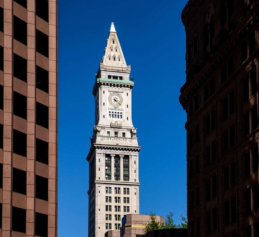
In the 20th century, the proud Custom House came to dominate a waterfront in decline. Instead of shipped goods, the vacant wharves began to store a different kind of commodity — parked cars for downtown office workers.
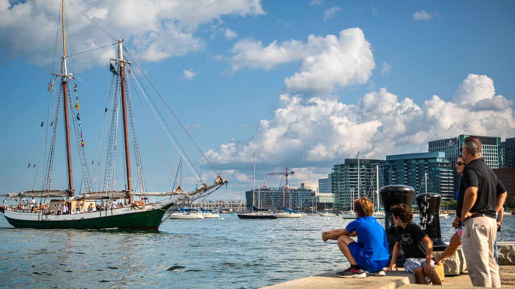
Within a generation, however, the bustle at Boston’s waterfront returned. The ships and longshoremen were gone. Great granite warehouses were converted to apartments, and cultural institutions, such as the New England Aquarium, were built. Hotels took choice waterfront locations. Tourist cruises and pleasure boats re-enlivened the docks. Today, the waterfront is once again crowded with activity, its uses re-imagined.
The Walk to the Sea intersects two other historic trails through Boston, the Freedom Trail and the Black Heritage Trail.
The Greek Revival style of the Custom House, completed in 1847, reflected both contemporary fashion and the building’s lofty purpose. The customs offices oversaw the sovereign interests of a young state and nation by supervising and taxing cargo.
The Custom House was built so close to the water that the bowsprits of arriving ships could touch it, though the shoreline has since moved.
Around 1913, the federal government built a 433-foot tower to enlarge the Custom House. For nearly a half century the tower dominated Boston’s skyline, while, ironically, waterfront activity and port services declined.
Finally, in the 1960s, investment returned to Boston and new skyscrapers began to form the modern skyline. Boston’s deserted wharves came back to life. Old warehouses and new buildings along the waterfront accommodated apartments, hotels, and cultural activities.
In 1995, after undergoing other changes of use, the Custom House was converted to timeshare apartments.
Here stood Boston’s "Highway in the Sky," so labeled in the 1950s by local media expressing the official hopes for a new elevated expressway.
Boston’s leaders chose to raze hundreds of homes and commercial buildings for the progressive project. The expressway was to decongest Boston's obsolete and crooked street network and "prune" away decayed portions of the city, inviting new investment downtown.
However, the highway and its supporting structure effectively cut off Boston's North End and waterfront from the rest of the city, and it came to be regarded as an eyesore. When traffic overwhelmed the expressway, Boston sought federal assistance to enlarge and bury the Central Artery, a project known as "The Big Dig."
The Rose Kennedy Greenway, completed in 2008, is a network of gardens and public spaces, named for the mother of long-serving, distinguished Massachusetts Senator Edward M. Kennedy and his brothers, President John F. Kennedy and New York Senator Robert F. Kennedy.
The mile-and-a-half Greenway extends from the Leonard P. Zakim Bunker Hill Bridge, past the North End and Wharf District, to Chinatown Gate. The Greenway serenely caps the massive traffic flow along the expressway buried beneath it.
The "Big Dig," a reconstruction of three-and-a-half miles of expressway, completed in 2007, became known as America's most expensive public works project. Today, traffic is routed underground, and now parks reconnect downtown Boston to the city's historic North End, wharves, and waterfront.
Like an arrow pointing back to the Old World, Long Wharf, built in 1711, dominated Boston Harbor. It reached well past approximately 80 other wharves bristling out from the Shawmut Peninsula. About a third of a mile long, it extended the town's main commercial street, King Street (now State Street), far into the harbor.
In addition to its prominent commercial role, Long Wharf witnessed the arrival of royal governors, chained pirates, British troops, and other historic spectacles. In 1774, British General Gage and his troops arrived here to quell Boston's rebellious spirit in a scene captured by Paul Revere’s engraving. Gage and his men fled Boston in 1776 from this same wharf.
When fugitive slave Anthony Burns was brought to the wharf in shackles in 1854, to be returned to slavery in Virginia, all of downtown Boston shut down and tens of thousands of people took to the streets in protest.
The sea is Boston’s front door. From the city’s inception, Bostonians relied on the sea for transportation, trade, defense, and the city’s expansion. Though these interests still influence the use of Boston Harbor, its public role as a cultural and recreational asset has received greater prominence since the 1970s.
Modern water transport includes commuter boats, water taxis, a shuttle to the airport, and cruises around the harbor and to several islands. While some goods still arrive in Boston by ship, much of the commerce around Boston’s harbor relates to tourism and recreation. As in colonial days, Boston’s harbor remains an important gateway to the nation
Landfill operations at Boston’s shoreline continued into the 1980s. Three great fill efforts during the 20th century created the land for Logan Airport, visible across the harbor. Modern as it is, the airport continues an important tradition. Even by air, people still arrive in Boston at the harbor.
John Winthrop was the first governor of the Massachusetts Bay Colony, and the chief figure among the Puritan founders of New England.
When, in 1629, the Massachusetts Bay Company obtained a royal charter to plant a colony in New England, John Winthrop joined the company, pledging to sell his English estate and take his family to Massachusetts if the company government and charter were also transferred to America. The other members agreed to these terms and elected him governor. He died, age 61, in the spring of 1649.
William Wood, The South part of New England, as it is Planted this yeare, 1639
More information about this Map from the Norman B. Leventhal Map and Education CenterSamuel C. Clough, Map of the Town of Boston 1648
Completed on 10 April 1919, this map by Samuel Chester Clough (1873-1949) shows property owners and land lots in Boston, Massachusetts, in 1648. This map informs his later maps of 1676 and 1798, as well as his atlas. An inscription on this map lists Clough's sources: "Drawn by Samuel C. Clough in accordance with information complied from the records of the Colony, Town, Registry of Deeds, Suffolk Probate, and Supreme Court; Book of Possessions, Winthrop Journal, Lechford Note Book, Aspinwall's Notes and City Surveys."
The map shows a densely populated Shawmut peninsula, especially the area around present-day State Street, Government Center, and Faneuil Hall. The hills, fields, and marshland all but disappear over the next century as the land was divided, sold, made, and developed. The map hints that the North End was practically an island, with a tidal creek connecting the Mill Cove to the Great Cove.
Clough also created a map of Boston in 1676 (please see the online display of Map of the Town of Boston, 1676), an atlas of Boston neighborhoods in 1798 (please see the online display of atlas of Boston neighborhoods in 1798), and a series of plate maps for 1798.
More information about this map drawn by Samuel C. CloughCourtesy of Massachusetts Historical Society
Lithograph by J.H. Bufford's after Watercolor by John Reubens Smith, 1811.
Courtesy of the Boston Public Library, Print Department.
James II and VII was King of England and Ireland as James II and King of Scotland as James VII, from 6 February 1685 until he was deposed in the Glorious Revolution of 1688. The last Roman Catholic monarch of England, Scotland and Ireland, his reign is now remembered primarily for struggles over religious tolerance.
Born: October 14, 1633, St James's Palace, London, United Kingdom
Died: September 16, 1701, Château de Saint-Germain-en-Laye, Saint-Germain-en-Laye, France
Children: Anne, Queen of Great Britain, Mary II of England
Spouse: Mary of Modena (m. 1673–1701), Anne Hyde (m. 1660–1671)
Parents: Charles I of England, Henrietta Maria of France
The original King’s Chapel was a wooden church built in 1688 at the corner of Tremont and School Streets, where the church stands today. It was situated on the public burying ground, now King's Chapel Burying Ground, because no resident would sell land for a church that was not Congregationalist (at the time, the Congregational church was the official religion of Massachusetts).
In 1749, construction began on the current stone structure, which was designed by Peter Harrison and completed in 1754. The stone church was built aroudn the wooden church. When the stone church was complete, the wooden church was disassembled and removed through the windows of the new church. The wood w then shiped to Lunenburgh, Novia Scotia, where it was used to construct St. John's Anglican Church. That church was destroyed by fire on Halloween night, 2001. It has since been rebuilt. Originally, there were plans to add a steeple, although funding shortfalls prevented this from happening.
John Bonner, A new plan of ye great town of Boston in New England in America, with the many additionall buildings & new streets to the year 1743.
More information about this Map from the Norman B. Leventhal Map & Education CenterCourtesy of The Bostonian Society/Old State House:
Boston Streets, 1910
Photograph Collection, ca 1855-1999
William Burgis, To His Excellency William Burnet, Esq., this Plan of Boston in New England in humbly dedicated
Dedicated to William Burnet who was acting governor in 1728, this is the second printed map of Boston. Although similar to Bonner's 1722 plan of the town, it was re-engraved and updated. Burgis reoriented the peninsula diagonally to accommodate a very elaborate cartouche and revised the list of churches to include Christ Church built in 1723. Because the Burgis map, like the earlier Bonner map, was invaluable in documenting the physical nature and life of 18th-century Boston, it was reissued numerous times during the 18th and 19th centuries. This facsimile was printed in 1869.
More information about this Map from the Norman B. Leventhal Map & Education CenterGeo H. Walker & Co., New map of Boston giving all points of interest : with every railway & steamboat terminus, prominent hotels, theatres & public buildings, 1894
More information about this map from the Norman B. Leventhal Map & Education CenterCourtesy of the Bostonian Society/Old State House: Boston Streets Photograph Collection, Ca 1855-1999.
This is a crowded Scollay Square in about 1942, two decades before it was torn down.
Courtesy of the Boston Public Library, Print Department: Leslie Jones.
For decades Simpson's Loan Company anchored the head of Cornhill in Scollay Square. When the city demolished the area in 1961-1962. Simpson's moved to Temple Place in Boston's so-called "Ladder District."
Photo circa 1950-1960
2004. Peter Vanderwarker.
Boston Town House, 1657
Lattre, Jean, (1764?), Plan de la ville et du port de Boston : capitale de la Nouvelle Angleterre.
This is the earliest detailed plan of the city of Boston published in France. Beautifully engraved and colored in the best style of French manuscript and printed maps, it shows streets, houses, public buildings, wharves, Beacon Hill, the Common, and other points of interest. Bellin, hydrographer to the King of France, published many fine maps of America under the auspices of the French Marine Office. This plan of Boston Harbor was probably copied from an English survey for use during the French and Indian War.
More information about this Map from the Norman B. Leventhal Map & Education CenterPaul Revere, The Bloody Massacre on 5th March 1770
Courtesy of the Massachusetts Historical Society / The Bridgeman Art Library
King Street, now known as State Street in 1873.
Courtesy of The Bostonian Society/Old State House: Boston Streets Photograph Collection, ca 1855-1999
1980. Peter Vanderwarker.
John Andrews, East View of Faneuil Hall Market in 1827
Courtesy of the Boston Public Library, Print Department
The print shows Dock Square, featuring the Old Feather Store. The store has two signs on the facing side, "CLOTHING" and "Charles J. Lovejoy." On the side of the building is a third sign, "CLOTHING WAREHOUSE." Other shops in the vicinity include Martin L. Hall & Co.; Manning, Glover & Co.; and William W. Allen Boots & Shoes. On the streets surrounding the stores are horse drawn carts, pedestrians, and a police officer directing traffic. Two boys are shown running across the street next to the officer. The Faneuil Hall Marketplace is visible in the distance.
The Old Feather Store was located on North Street in Dock Square. The building was constructed by Thomas Stanbury in 1680. It was owned and run by a number of successive retailers, and this lithograph shows the name Charles Lovejoy, who sold clothing in the early 19th century. The building was demolished in 1860.
Justin Winsor, Boston Old and New
Noted historian and librarian, Justin Winsor created this unique map by superimposing the outline of the original Shawmut Peninsula onto an 1880 map of Boston. It was used as the frontispiece for the first volume of his "Memorial History of Boston, Including Suffolk County, Massachusetts", published in 1882. Though drawn without the assistance of computers or aerial photographs, it remains one of the most vivid diagrams of the radical transformation and enlargement of the Shawmut Peninsula during the 19th century.
More information about this Map from the Norman B. Leventhal Map & Education CenterJ.H. Buffords, publisher
(Boston, 19th Century)
Mercantile Building Summer Street in 1891
An 1929 aeriel view of Adams Square and Quincy Market. Quincy Market was built on top of the Town Dock in 1824, bringing ships and cargo right to the back door until the city expanded and the shoreline moved east.
Auhor: Aerial Scenic Airviews in 1929
Courtesy of the Boston Public Library, Print Department.
Boston Custom House in 1847
Custom House, n.d. in 1888
Courtesy of The Bostonian Society/Old State House
The Custom House after the addition of the tower in 1916.
Courtesy of The Bostonian Society/Old State House: Boston Streets Photograph Collection, ca 1855-1999.
From the Malcolm Woronoff Family, Aerial Photos International Collection.
Copyright held by the Frances Loeb Library, Harvard Graduate School of Design.
Construction of the Central Artery in 1954. Quincy Market is in the front.
Courtesy of the Boston Public Library, Print Department, Leslie Jones
Image © Andy Ryan.
2003. Google Earth
Rubble, 2004
Courtesy of Christian Waeber Photography
Courtesy of The Greenway Conservancy
John Bonner, The town of Boston in New England
Bonner's 1722 map depicts Boston before centuries of landfill transformed its coastline. His distinctive design combines plan and perspective views to convey maximum information and achieve decorative effect. It shows clearly the patterns of settlement, dense in the North End and along Cornhill and King Streets but thinning toward the south and west. The abundance of wharves, shipyards and ropewalks reflects Boston's flourishing maritime economy. Captain Bonner was more comfortable drawing sailing vessels than topography: the shipping in the harbor is carefully rendered, whereas simple bumps near the Common represent the "Trimontane" that once dominated the town.
More information about this Map from the Norman B. Leventhal Map & Education CenterPaul Revere, Jr., A view of Part of the Town of Boston in New-England and Brittish [sic] Ships of War Landing their Troops! 1768, [1] 1770, Boston. Engraving with hand-coloring.
Courtesy of the Boston AthenæumGeorge-Louis Le Rouge, Plan de Boston avec les sondes et les directions pour la navigation : traduit de l'anglais
Boston and other nearby towns, many of which were depicted pictorially, are located on this 1778 French chart of Boston Bay. Boston, with city blocks colored in different shades, covers most of the peninsula. The harbor is shown with navigational information such as islands, shoals, soundings, and channels. A note following the title indicates that the chart was based on British surveys. Le Rouge, the chart's publisher, is known to have published several volumes of maps, charts, and city plans relating to America from 1755 to 1778, many of which were based on the best contemporary English maps.
More information about this Map from the Norman B. Leventhal Map & Education CenterView of wharves in Boston: Commercial Wharf to T. Wharf.
Photograph by Augustine H. Folsom, circa 1874
Courtesy of the Massachusetts Historical Society
State Street Elevated Railway Station, ca. 1914